
Met Éireann confirms Storm Ashley to hit Ireland amid STATUS ORANGE warnings

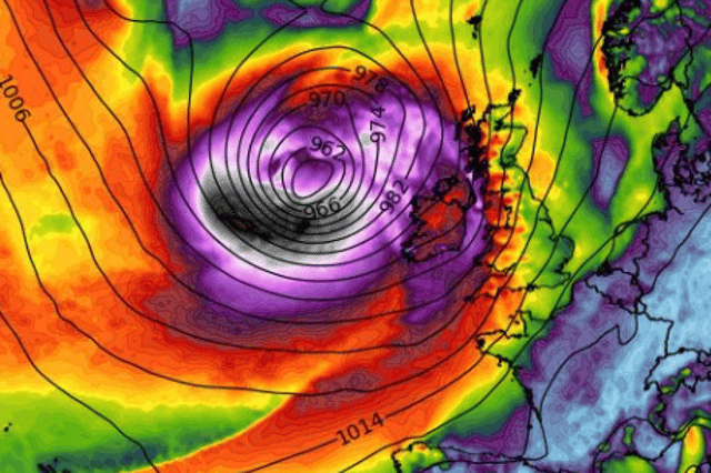

The brutal low pressure system will makes its presence felt on Saturday night and Sunday morning
Met Éireann has confirmed that Storm Ashley will hit Ireland late on Sunday and wreak havoc with strong winds and possibly thunderstorms and flooding. The national forecaster has issued a raft of warnings related to the low pressure system which is deepening as it approaches our west coast.
The most serious warning issued so far is a Status Orange wind warning for Galway and Mayo which comes into effect from 12 noon on Sunday.
"Storm Ashley will bring very strong and gusty southerly winds, coupled with high spring tides," Met Éireann warns.
They say impacts include "coastal flooding, large coastal waves, loose objects displaced, fallen trees, very difficult travelling conditions, dangerous conditions at sea, damage to power lines, power outages and damage to already weakened structures."
This warning is valid until 9pm on Sunday night.
Elsewhere, a Status Yellow wind warning has been issued for the rest of the country, including Northern Ireland.
In that warning, Met Éireann says "Storm Ashley will bring strong and gusty southerly winds, coupled with high spring tides."
The impacts outside the orange counties still include coastal flooding, large coastal waves, some fallen trees, as well as difficult driving and cycling conditions and the possibility of debris, loose objects displaced.
This nationwide warning is valid from 10am to midnight on Sunday.
Met Éireann general outlook for Sunday adds: "Becoming very windy on Sunday. Rain will clear quickly to the northeast on Sunday morning to leave a day of sunny spells and blustery showers. More persistent rain will return to some western and northern areas during the afternoon with a few thunderstorms possible.
"Strong to gale force southwest winds will bring the potential for some disruption, especially in Atlantic coastal areas. There'll be the ongoing risk of coastal flooding due to a combination of high seas and spring tides. Highest temperatures of 12 to 15 degrees. Continuing very windy on Sunday night with clear spells and scattered blustery showers. Lowest temperatures of 7 to 10 degrees."
There is some good news beyond that as they say "winds will ease on Monday to leave a predominantly dry day with sunny spells and just a few showers in Atlantic coastal counties."